
Water levels in Lake Winnebago are controlled by two dams: one in Neenah (privately owned) and one in Menasha. The dam in Menasha is operated by the Army Corps of Engineers. The Army Corps regulates water levels for Lake Winnebago under a 1886 Marshall Order to maintain the level of the lake at or below flood stage (3.45 Ft. at the Oshkosh gauge) and above 1.68 Ft during the navigation season.
Please note: These water level values are in reference to a certain elevation in relation to the dams (Oshkosh Datum) and DO NOT represent lake depth.
The dams have been in place for over 150 years. During this time, a variety of users (both upstream and downstream of the dams) have come to rely on the water in the lakes (including outflows to the Fox River). Their interests are often competing with one group’s optimal being at the detriment of another. The Army Corps attempts to find compromise among these users as a way to satisfy varying user demands within their regulation limits. Despite their attempts, the public meetings hosted by the Army Corps each year did not always result in constructive conversations among stakeholders.
In 2018 a group of stakeholders who recognized that timing and depth of water levels had historically and continued to cause substantial damage to the Winnebago Lakes were determined to find another way forward. High spring-time water levels is one of the drivers of poor water quality, loss of habitat, and destruction of aquatic plant communities. This group initiated discussions with other lake users and downstream stakeholders. The goal was to work together to find a compromise across a variety of interests. The result was a recommendation to the Army Corps for an annual water level management strategy that provides summer and fall water levels appropriate for summer and fall recreation boating while allowing for a slightly slower spring refill to encourage habitat recovery, better water quality, and reduced the risk of shoreline erosion.
To learn more about water levels, check out the DRAFT Water Level Management report by clicking the image above.
Check out other reports and the draft Winnebago Waterways Lake Management Plan by clicking HERE.
The recommendations were:
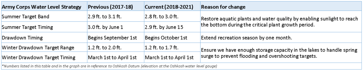
1.) Shift summer target (green band) down 1.2 inches (the height of a standard paper clip).
2.) Hold water levels toward the lower end of the target band, when possible.
3.) Extend summer target to October 1st for fall boating.
4.) Shrink winter drawdown target range.
These recommendations represented very slight adjustments to the strategy that was already in place. A comparison is shown in the table below.
Each fall, the Army Corps revisits their annual water level strategy and makes adjustments, if needed. The Army Corps took the recommendations from the diverse group of stakeholders into consideration during their fall public strategy meeting. Based on public opinion (after a public comment period and an additional public meeting), the Army Corps implemented these recommendations for 2018-2019.
We were looking forward to seeing the adjusted strategy in action in 2018-2019. Unfortunately, Mother Nature had different plans for Lake Winnebago and the area of land that drains to the lake. Three of Wisconsin’s top five wettest years have taken place in the last five years (2019, 2018 and 2016). Wetter than average conditions in the Fox-Wolf Basin combined with high soil moisture, snowpack, and depth to frost (among other conditions) have made it challenging for the Army Corps to stick to the annual strategy. As a result, water levels, on average, have been higher than normal over the past few years with several instances of significant overshoots of water level targets.
Preparing for the Worst – Winter Drawdown 2020
This purpose of winter drawdown each year is to create room for Lake Winnebago to store water. This helps to prevent flooding around the lake because every spring, at some point, inflows exceed outflows leading to uncontrolled rise in lake level.
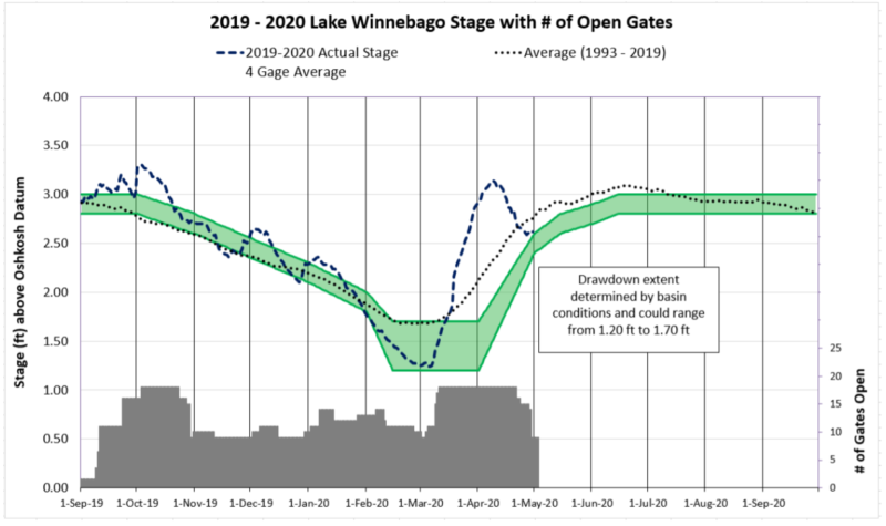
The exact drawdown target is decided by the Army Corps after a public conference call that is held each winter. They make their decision based on public input and conditions in the watershed (snowpack, depth to frost, precipitation forecast, and weather outlook). Remember – the snow that melts up north (as far as Crandon) and does not evaporate or soak into the ground ends up draining to Lake Winnebago. In preparation for the potential of high inflows this spring, the Army Corps dropped Lake Winnebago to 1.25 ft. (Oshkosh datum) which is about as low as the lake can be before impacting water intake for certain industries.

Lake Winnebago serves as the outlet or “drain” for over 5,700 square miles of land. This represents ~10% of the land area of Wisconsin. These watersheds are called the Wolf River (top gray area in map) and Upper Fox (lower portion) Basins.
The water that runs off of the land in these watersheds are the ‘inflows’ to Lake Winnebago. The water that exits Lake Winnebago through the dams is called ‘outflow’. The dams, even when all of the gates are open, can only allow so much water to pass through. When inflows exceed outflows, there is an uncontrolled rise in the water levels of the lake. This most often occurs during early spring as snow melt and precipitation leads to high inflows to the lake.
Hoping for the Best – Spring Refill 2020
Even though the lake was as prepared as it could be for the spring flush, high amounts of precipitation caused inflows to the lake to greatly exceed the outflow capacity of the dams. This led to a significant overshoot of the spring refill targets even though the Army Corps provided as much storage in the lake as possible (without impacting industry and trying to reduce impacts to downstream property owners caused by high outflows).
The graph below shows the annual Army Corps strategy which is represented by the green band. This is referred to as the target band. The Army Corps manages outflows at the dams to try to keep average water levels in the lakes within the target band.
The dotted line shows average water levels from 1993 to 2019. The difficulty of managing lake level rise this time of year is evident – lake levels are typically above the target during spring refill.
The dashed line shows average daily water levels so far this year (2020). Even though the lake was drawdown in preparation and the Army Corps had as many gates open as possible (gates are shown at the bottom of the graph in gray), the lake was well above the target band until the end of April.
Refilling to Summer Targets in 2020
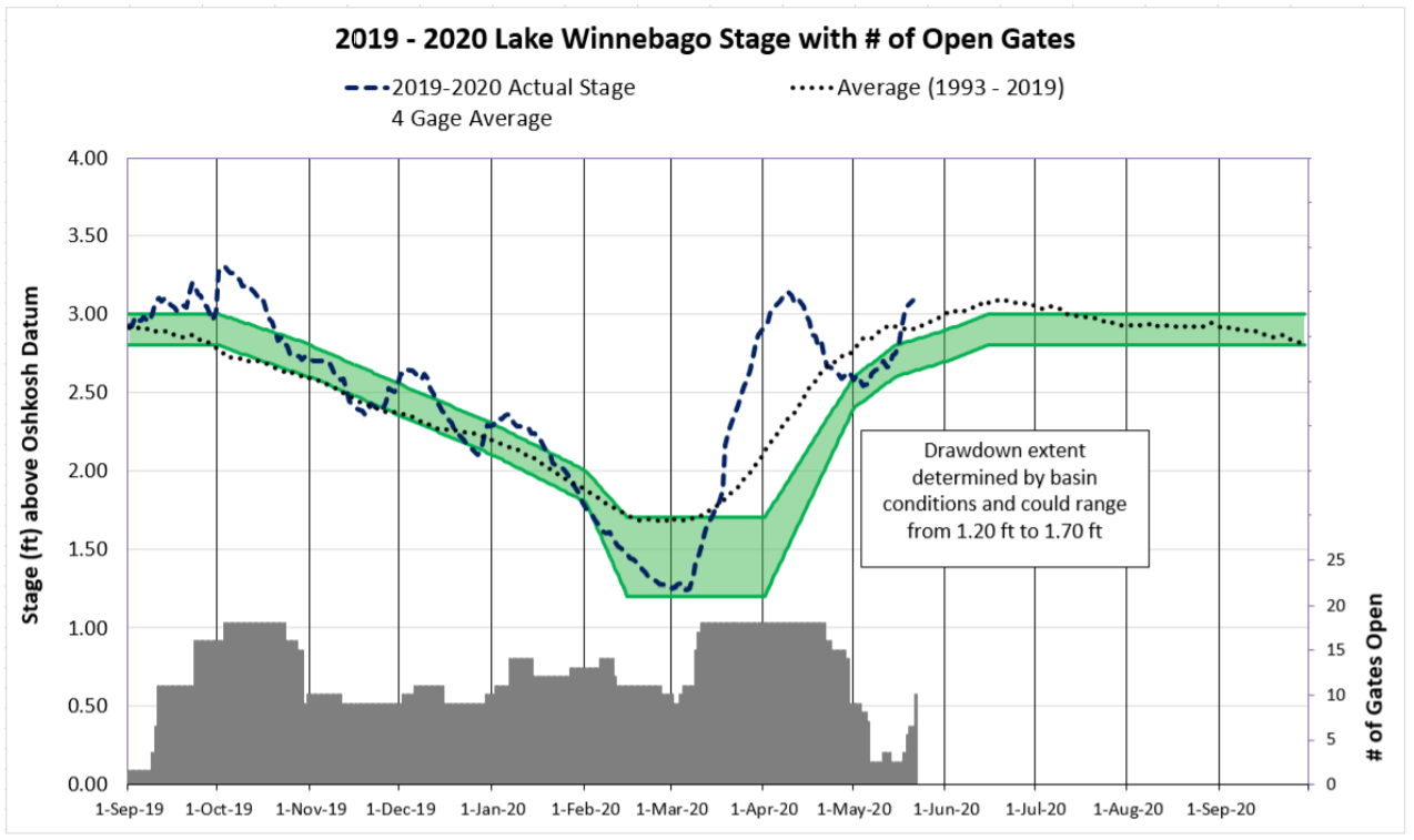
The Army Corps diligence in their efforts to regain control of water levels in Lake Winnebago and the cooperation of Mother Nature got the lake back on track in early May. As shown in the graph below the lake was at the mid-range of the target strategy until recent wet weather. We applaud the Army Corps for their efforts.
Unfortunately, heavy rains in the watershed brought an additional two inches of water to Lake Winnebago. Direct rainfall over the lake along with drainage from the watershed caused the lake to rise significantly from the levels observed in early May. The Army Corps has re-opened several gates in response to the heavy rain and in preparation of the upcoming forecast.
Even with the gate openings, we are once again above the agreed upon target for this time of year. The lake was around 3.09 feet above the Oshkosh datum on Friday morning (May 22, 2020). It is critical that the lakes are brought back down to the target range (2.6 ft to 2.8 ft at the Oshkosh datum) for this time of year and allowed to slowly refill to the summer navigation target of 2.9 ft. by June 15th. The graph below was clipped from an Army Corp update available on their website.
Ongoing Communication
On behalf of Fox-Wolf Watershed Alliance and the Winnebago Water Level Assessment Team, I want to thank the Army Corps for their hard work over the past several months as well as express appreciation for their ongoing communications regarding lake levels, basin conditions, and gate status. They do a great job of collecting public input throughout the year and posting updates on conditions to their website: CLICK HERE
An opportunity to be part of the conversation
For those who may be interested in being an active voice in discussions related to water levels in Lake Winnebago, we invite you to consider joining the Winnebago Water Level Assessment Team (WWLAT). The purpose of the WWLAT is to provide opportunities for lake users, other stakeholders, and experts to collaboratively develop realistic and achievable water level strategy recommendations that reasonably balance the top priorities of multiple system users and the health of the lakes. If you are interested, please contact Korin Doering at korin@fwwa.org or (920) 851-0948.

For those of you who would like to see better water quality in Lake Winnebago and fewer blue-green algae blooms, following the target band for a gradual refill is important. The month of May is critical for aquatic plant growth. Aquatic plants are directly linked to water quality (and make up the base of aquatic habitat).
Fewer plants = more frequent and intense harmful blue-green algae blooms
More plants = fewer and less intense harmful blue-green algae blooms
We included a few photos of blue-green algae blooms on Lake Winnebago to remind people just how bad it gets every year.

Article date: first published on 05/07/2020; updated on 5/23/2020
Follow the Fox Wolf Watershed Alliance’s Winnebago Waterways Program on our Winnebago Waterways Facebook page or @WinnWaterways on Twitter! You can also sign-up for email updates at WinnebagoWaterways.org.
Questions? Comments? Contact Korin Doering, Director of the Winnebago Waterways Program, at (920) 851-0948 or korin@fwwa.org.
Winnebago Waterways is a Fox-Wolf Watershed Alliance program. The Fox-Wolf Watershed Alliance is an independent nonprofit organization that identifies and advocates effective policies and actions that protect, restore, and sustain water resources in the Fox-Wolf River Basin.