
The Army Corps of Engineers – Chicago District regulates water levels in Lake Winnebago by regulating outflow at the dams in Menasha and Neenah under the Federal Marshall Order of 1886. The Marshall Order is intended for flood risk management. The Order defines the limits of regulation for Lake Winnebago (referenced to the Oshkosh Datum):
May 1st to October 1st (navigation season):
- High end of limit: 3.45 ft.
- Low end of limit: 1.68 ft.
October 2nd to April 30th:
- High end of limit: 3.45 ft.
- Low end of limit: 0.18 ft.
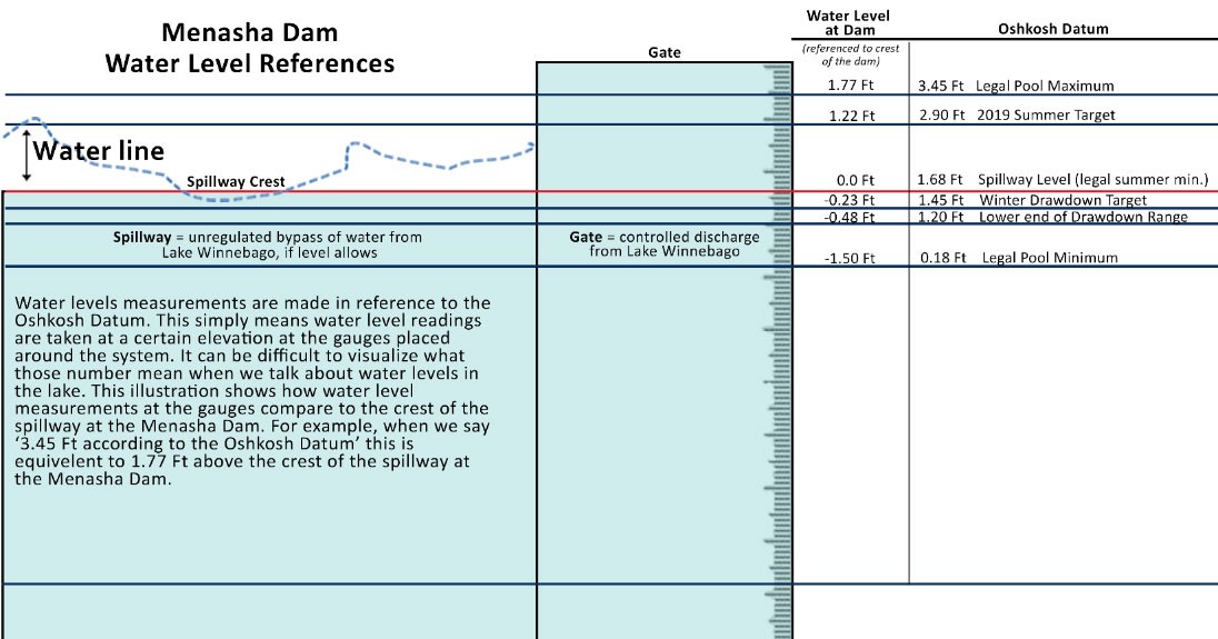
The Oshkosh Datum refers to a local, historic elevation point that was, at one time, referenced to the crest of the Menasha Dam. Even though the physical location no longer exists in Oshkosh, this reference system is still used to communicate surface water elevations for Lake Winnebago today. For example: 1.68 ft. at the Oshkosh Datum means the average level of the lake is equal to the elevation of the crest of the Menasha Dam. The illustration below provides a comparison.
While meeting their mission of flood risk management is the priority, the Army Corps also tries to meet the needs of various stakeholders within their operating limits. This requires finding a reasonable balance among multiple competing interests.
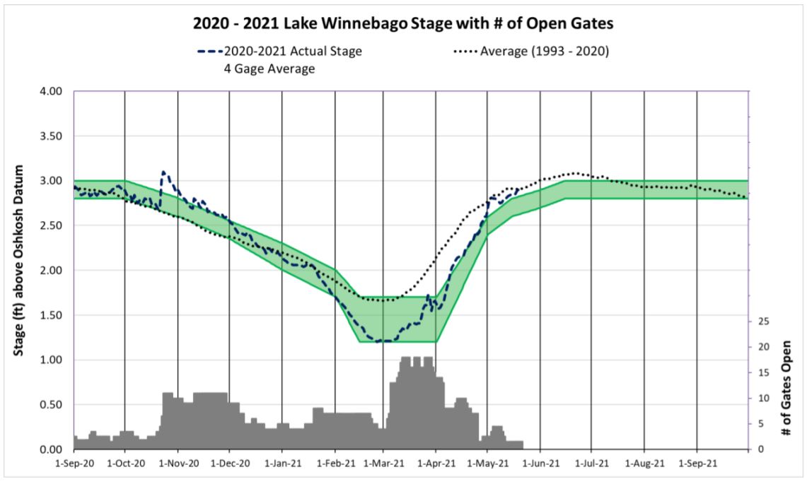
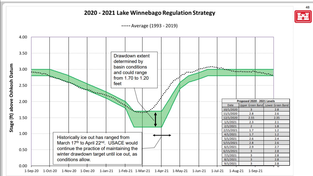
Their annual regulation strategy represents that balance and can be broken down by certain times of the year: fall drawdown, winter pool, spring refill, and summer pool. Water level targets are set along this strategy in a schedule. These targets are listed in the Army Corps 2020 – 2021 Lake Winnebago Regulation Strategy (shown in the image below).
The annual strategy is kind of like a proposed schedule. For many boaters, refill is of particular interest. According to the most recent annual strategy, refill targets are as follows (at the Oshkosh Datum):
- May 1st – 2.5 ft (Operating band: 2.4 to 3.6 ft)
- June 1st – 2.8 ft (Operating band: 2.7 to 3.9 ft)
- June 15th – 2.9 ft (Operating band: 2.8 to 3.0 ft)
Average Water Level for Lake Winnebago
When it comes to water level of Lake Winnebago we are typically referring to an average of four gages located around the Lake. Local water level at a given location within the Lake can vary. It is not uncommon for lake level to be near a foot in difference between Menasha and Fond du Lac gages during strong, sustained winds.
More information about gages and the elevation of the water’s surface is provided in a document the Army Corps handed out at their 2021 Spring Refill meeting (CLICK HERE).
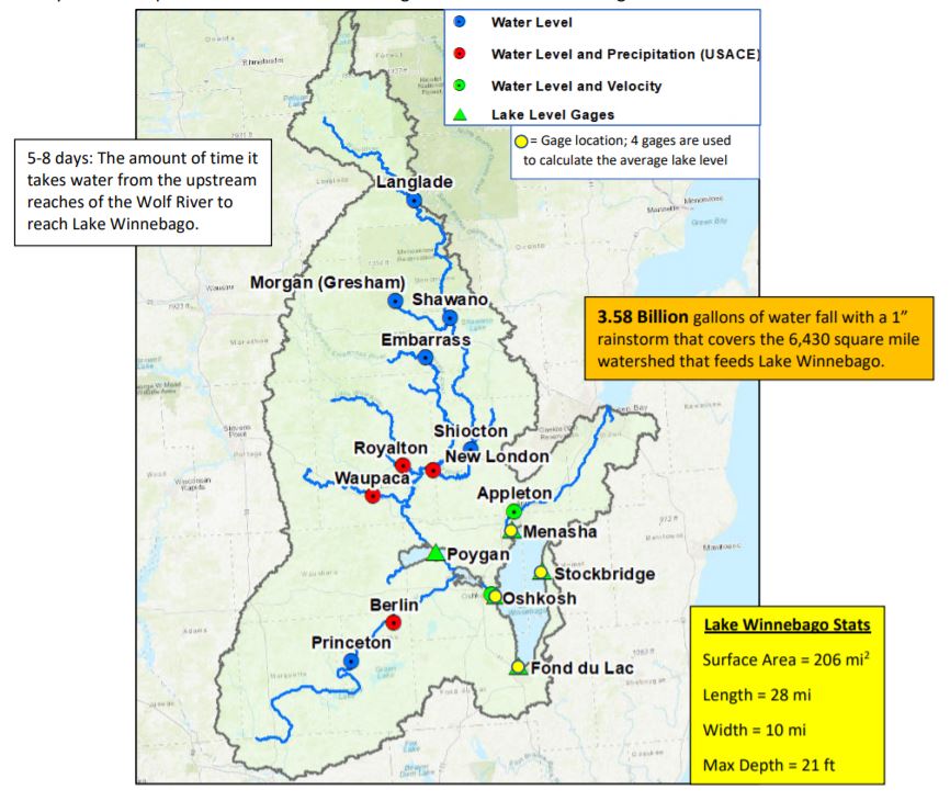
Gage locations. Lake level gages are represented by the yellow dots. Image credit: ACOE.
Using the Army Corps Website:
The Army Corps provides access to a lot of data and information through their Lake Winnebago webpage: CLICK HERE
Here is a summary of some of the helpful information that can be found on the Army Corps website:
- Lake Winnebago Regulation Strategy 2020-2021: the water level regulation schedule for this year. The schedule starts on October 1st and runs to September 30th each year.
- Current Conditions: a weekly update that is published each Friday with a description of conditions as well as an updated graph. You’ll notice that the graph provided in the weekly update from April 9th shows water levels are on the rise. Note: the water levels shown in that graph represent an average of the four gages located around Lake Winnebago. Local conditions at a given site may vary.
- Lake Winnebago Levels and Flows
- NOAA River Links: interactive maps that indicate flood stage for various rivers
- Observations: flood stage indicators based on measurements taken from gages location on the rivers/streams
- Forecasts: NOAA’s predictions for river stage and potential for flooding
- Levels and Flows: links in this section provide hourly and daily lake levels and flows for the gages (see attached image) the Army Corps uses to inform their management decisions for the dams.
- Lake stage (water level): Lake Winnebago’s stage (water level) is taken as the average of the levels at gages located in Oshkosh, Stockbridge, Menasha and Fond du Lac. Lake Poygan has one gage that is used near the mouth of the Wolf River. There is a newer gage on Lake Butte des Morts that is not yet online because it is unable at the moment to connect to the satellites used to transmit data. Linking the gage to the satellite is in progress.
- Tributary Inflows to Lake Winnebago: inflows to Lake Winnebago from the Upper Fox and Wolf River Basins are estimated using measurements from a network of stream gages. Gages are located in New London, Berlin, Waupaca, and Royalton.
- Inflows at Oshkosh: Inflows to Lake Winnebago are measured using data collected from a gage located in the Fox River in Oshkosh.
- Outflows: outflows from Lake Winnebago are estimated using measurements taken from a gage located in the Fox River in Appleton.
- Historical Data (Experimental): this is one of my favorite resources on the Army Corps webpage because I am very much a visual person. These links provide graphical representation of the data listed in the tables under Levels and Flows. If you look at the top graph with the lake gages, you can see the storm surge and seiche effects over the past couple of weeks. When Fond du Lac is high and Menasha is low, that tells us that the wind was pushing water from the north to the south end of the lake. Then we see the “sloshing” effect after a big wind push as the lake sloshes back and forth trying to level back out.
- NOAA River Links: interactive maps that indicate flood stage for various rivers
- Basin Precipitation
- Various links to precipitation, weather, and snow depth data. Snow depths are important for determining winter drawdown depth and timing.
- Basin Water Temperature
- Links to water temperature recordings. Water temperature is important because it helps provide insight to ice conditions on the water, indicates the likelihood of frazzle ice forming on the Lower Fox River, and certain water temperatures trigger various life cycle processes in our aquatic flora and fauna. For example, many of our native aquatic plants begin to emerge around 55 degrees Fahrenheit.
Additional Water Level Related Information:
1.) Water Level Management for the Winnebago Waterways: This report describes water level management including the process of developing an annual strategy, the considerations for the strategy, and the reason the strategy (schedule) is in its current form. CLICK HERE for the report.
Please note: after the report was written, the Army Corps when through redistricting. Management of Lake Winnebago water levels transitioned from the Detroit District to the Chicago District. This has not yet been updated in the report linked here.
This report is part of a larger planning effort for the Winnebago Lakes. The rest of the lake plan can be found here: https://fwwa.org/lake-management-planning-2/
2.) Winnebago Water Level Assessment Team (WWLAT): This is a stakeholder group that holds discussions about water levels independent of the Army Corps public input process. The website for the Team provides information about the background, past recommendations, and more. Interested stakeholders are welcome to participate.
Link: https://fwwa.org/winnebago-waterways/wwlat/
Contact: Korin Doering, Winnebago Waterways Program Director, (920) 851-0948 or korin@fwwa.org