
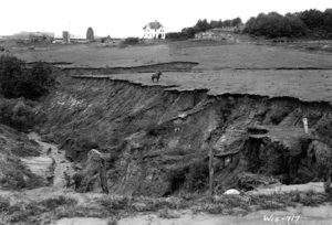
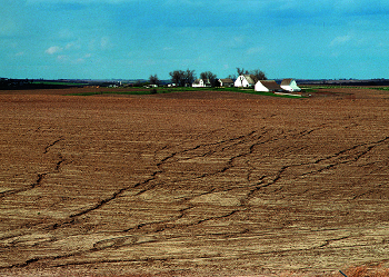
Coon Creek erosion – Photo: NRCS
By 1930, landowners and farmers in southwest Wisconsin’s Coon Creek watershed were ready for a change. Enticing wheat prices in the mid to late 1800s had led to every arable acre in the watershed being cropped. The commonly practiced wheat on wheat rotation ultimately burnt out the soil and led to crop disease. Livestock production came to dominate the landscape when the wheat growers moved west in search of better land. The valleys and gentler slopes were cropped for feed and grain, and the land too steep to crop was grazed. Rectangular fields of intensively worked straight crop rows, along with heavy grazing pressure, just didn’t work in the Coon Creek watershed, and it was showing. When rain hit the steep Coon Creek slopes, it ran with an unstoppable force down the naked landscape and carried the soil with it. Gullies erupted where the torrents congregated, resulting in canyons that made farming nearly impossible, and polluted some of the best trout streams in the country.
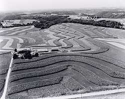
Coon Creek strip cropping and contour farming – Photo: NRCS
The dramatic loss of one of our state’s most precious resources did have some gain. The expansive gullies and washouts caught the eyes of our nation’s early soil conservationists, who found that the Coon Creek watershed would make a great site for the first watershed scale soil conservation project. Many farmers, interested in and eager for a solution, readily joined the project. By 1935, more than half of the valley’s 800 farmers had signed cooperating agreements. To make a very long story short, the newly formed Soil Erosion Service partnered with the farmers, and aided by the Civilian Conservation Corps, began working on hundreds of acres. Some projects and practices included reforesting pastures, filling in and vegetating gullies, strip cropping, contour farming, fencing off woodlots, and stream bank restoration. Most farmers were obliged to continue the practices for five years, and then, if desired, could return to their old practices. Out of free choice, they did not.
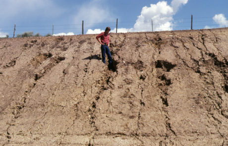
Erosion in the context of the Winnebago System, is simply soil loss. It technically is a naturally occurring process. In pre-settlement times, soils in the upland worked their way down the watershed. But it was slow. Slow enough to measure in geologic time. There were thousands of landscape features that slowed the march downstream towards Green Bay, and ultimately to the Atlantic Ocean, making this trip take a millennia. When these impediments, like forests, wetlands, and vast prairies are removed, nothing anchors the soil down to the Earth, or slows down the flow of water. This makes soil incredibly vulnerable to wind and water. It results in erosion rates that are measured in tons per acre per year. Read that again – tons per acre per year.
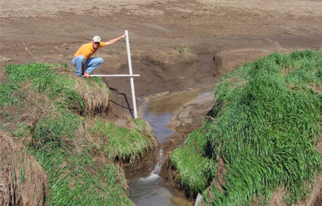
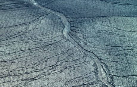
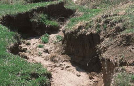
There are three main types of water induced erosion that we see in our area. The most conspicuous is gully erosion. Gully erosion is what most people think of when they think of erosion. Gullies occur when concentrations of runoff cut large channels into the soil. Rill erosion has occurred when there are small but numerous water channels or rivulets on the landscape. Sheet erosion is inconspicuous, uniform soil loss across an area.
Erosion happens when the force of rain or wind overcomes the ability of soil to stay in place. There are a lot of factors that go into keeping soil where it belongs, and you can read more about them here.
Losing soil from a field is detrimental to the field itself, but it also has profound impacts on our waters. Erosion, whether it is on a stream bank, a road cut, a construction site, or a farm field, carries sediment that is laden with phosphorus and other nutrients. The impact is two fold. First, the phosphorus fuels the explosive blue-green algae blooms that we see multiple times a year on our system. When our system’s influx of phosphorus is much greater than it can naturally handful, the excess is utilized by blue-green algae. Second, the sediment inhibits the sun’s ability to penetrate the water column and promote plant growth. Without healthy native vegetation, there aren’t any plants to utilize the excess phosphorus, so hardly any competition for the blue-green algae exists. It gets even more interesting than that, and you can read further about the extensive effects of sediment pollution here and phosphorus pollution here.
There is an ethos that believes that erosion is “just part of it.” Ditches running with a torrent of chocolate milk colored water don’t have to be a seasonal occurrence. Streams banks don’t have to be falling apart. There are so many ways erosion can be reduced, and the health of our waters unarguably depends on that reduction.
Reducing erosion is one of the most important components of the Lake Management Plan that is being developed for the Winnebago System. The LMP can do this by helping to find partners and funds for projects like stream bank stabilization/restoration, grassed waterways, or equipping farmers with resources like no-till seed drills. Creating opportunities to learn about and share information about new agriculture practices, like what Fox Demo Farms is doing, is another way the LMP can reduce erosion and run-off. We can also work on projects like wetland restorations, which will help soak up and filter runoff before it makes it way into our water bodies. These are just a few examples. Erosion happens in so many ways, and the cumulative effect of many successful projects is what is really going to turn our system around.
Winnebago Waterways is a Fox-Wolf Watershed Alliance program. The Fox-Wolf Watershed Alliance is an independent nonprofit organization that identifies and advocates effective policies and actions that protect, restore, and sustain water resources in the Fox-Wolf River Basin.
Follow the Fox Wolf Watershed Alliance’s Winnebago Waterways Program on our Winnebago Waterways Facebook page or @WinnWaterways on Twitter! You can also sign-up for email updates at WinnebagoWaterways.org.
This post was written by Austin Pethan for the Winnebago Waterways Program. Questions or comments? Contact Austin at austin@fwwa.org or (920) 920-851-4295.