
Project Overview
Kalbus Country Harbor is an RV-park and campground located along the western shoreline of Lake Winnebago on Lake Road in Oshkosh, Wisconsin. The campground and adjacent property, purchased in early 2021, is owned and managed by Team SNW, LLC. In late 2021, Team SNW approached the Winnebago Waterways Program at Fox-Wolf Watershed Alliance with the idea of incorporating a wetland restoration project into their development plans for the property on the west side of Lake Road. From there, additional partners became involved with the project. This includes Wisconsin Waterfowl Association and Winnebago County LWCD. With help from all of the project partners, Team SNW, LLC. has since advanced the project with plans to restore three wetland areas in summer 2022. We are very excited to be part of this project and look forward to showcasing project progress as work advances!
Direct link to this page:
www.fwwa.org/kalbus
Project Goal
This project aims to restore several acres of wet meadow, hardwood-swamp, and grassy meadow from its previous agricultural use to a natural state with native vegetation to protect the environment, wildlife, and waterways.
Project Objectives
- Increase the amount of high quality wetland and grassland habitat available to wildlife along the west side of Lake Winnebago.
- Reduce the amount of phosphorus and sediment pollution that reaches Lake Winnebago.
- Provide recreational opportunities for the public and campground guests in high quality natural areas.
- Provide educational opportunities to the public that showcase the importance of wetlands, grasslands, and native plants.
- Provide educational opportunities for K through Higher Education to expand interest and outreach into environmental/ecosystem health issues.
Site Description
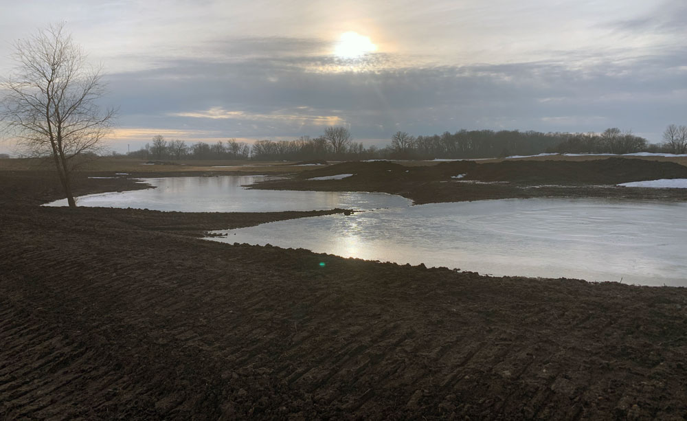
The property is roughly 52 acres in size and, prior to restoration, consisted of open field (cropland), fresh meadow, degraded hardwood swamp, main-house, rental house, workshop, and cottage in addition to the RV-Park and campground. Wetland indicators on this property were mapped and delineated by Merjent in 2022 (see map). The restored area will be just over 33 acres.
The project property is surrounded by agriculture typical of the area and single family residences to the north and south. Lake Road divides the property and Lake Winnebago borders the property’s eastern edge. Two drainage ways, one to the north and one to the south running under Lake Road, will be restored to look more like natural creek beds. Neither drainageway has stream history or was deemed navigable, including the drainageway running west to north through the middle of the agricultural field on the property.
The restoration will clear undesired hardwood debris, remove undesired sediments that have filled the existing fresh meadows and swamp, create new berms and spillways, and replant native vegetation. The potential to install a phosphorus removal system is also being explored. This project site plan describes the project goals and objectives, pre-restoration conditions, design details, funding sources, project budget, and relevance to regional restoration goals.
Project Design Overview
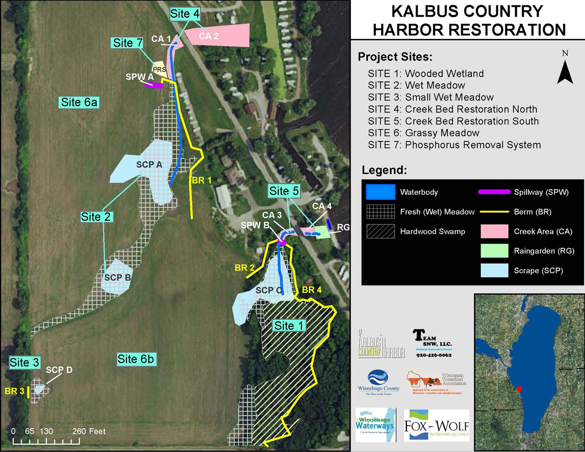
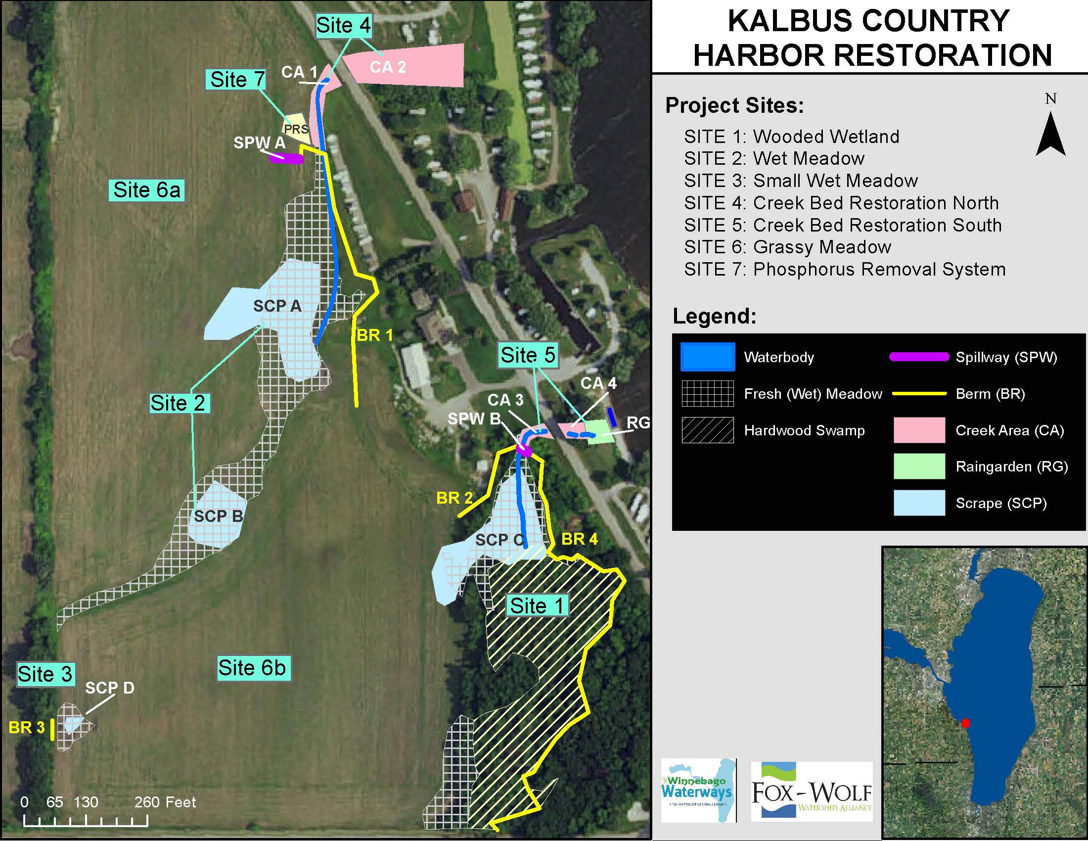
To meet the project goals and objectives, the project was divided into seven different restoration sites:
- Site 1: Wooded Wetland (3.38 acres)
- Site 2: Large Wet Meadow (2.33 acres)
- Site 3: Small Wet Meadow (.11 acres)
- Site 4: Creek Restoration North (0.03 acres)
- Site 5: Creek Restoration South (0.22 acres)
- Site 6: Grassy Meadows (27 acres)
- Site 7: Phosphorus Removal System (potential is being explored)
The project will restore wetlands over original hydric soils using scrapes and berms. Creating shallow areas of pooled water will attract wetland wildlife, including waterfowl, on land formerly converted to cropland from wetland. This will include three berms, four scrapes, two creek restorations, grassy meadows, and a potential phosphorus removal system.
The project will retain water on site by removal of the artificial drainage features. All three wetland restoration sites contain surface water drains which will be reversed to restore hydrology. The two smaller areas will have simple berms placed across the ditches that are currently draining the wetland area. This will restore hydrology to an elevation of natural ground prior to artificial drainage. The center area will have a berm built across the grassed waterway to slow and pond water during runoff events to allow sediment and nutrients to settle out. A minimum 35 ft. buffer of native prairie will be established around the finished wetland boundaries. Additionally, new wells will be drilled to help maintain water levels for Sites 1 and 2. Two new water level control structures will be placed in the spillways to regulate water levels and flow rates.
Thousands of plant plugs will be distributed between each Scrape Area and the Creek Restorations. Berms will be extended by creating mowed walking paths. Both spillways will be vegetated and reinforced with TRM (turf reinforcement mat) netting and seeded with a native wet and dry prairie meadow seed mix. Bridges (to be determined) and Boardwalks (to be determined) will be built and installed as determine by the final onsite design. Educational Signage will be developed once the construction is complete and strategically placed along walking paths.
In May 2023, over 2,000 plant plugs of native plant species were installed at the site with the help of numerous volunteers! The plants will continue to grow and support the wetland restoration.
Project Funding and Partners

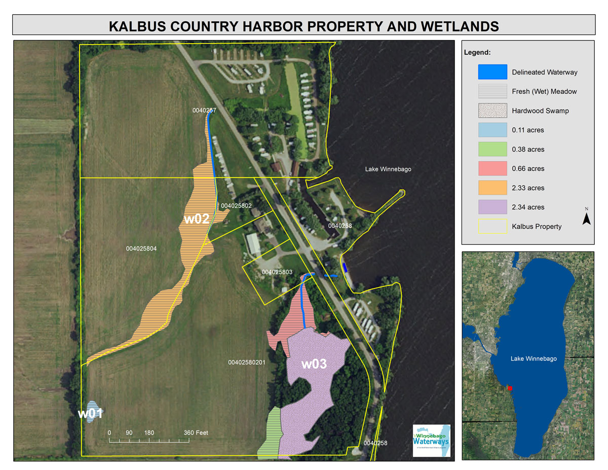
Map of the property and wetland delineation. W01 is the smallest wet meadow on the property. W02 is the large wet meadow. W03 is the wooded wetland with some wet meadow.
Working Towards the Goals of Regional Plans:
This multi-partner project helps the system progress toward habitat restoration and water quality improvement goals outlined in several agency management plans, such as:
Project Updates – Planting completed in May 2023!
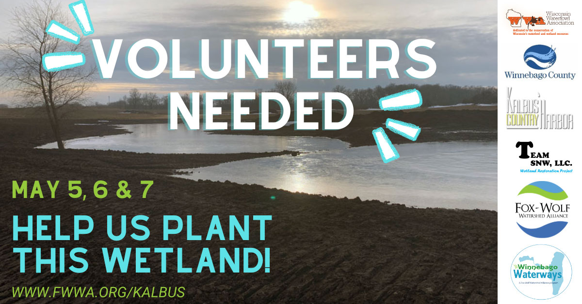
Volunteers needed – Wetland Restoration Planting
We are looking for 10-15 volunteers to help plant 2,720 plant plugs for a wetland restoration on the west side of Lake Winnebago. Volunteers [...]
Kalbus Wetland Project Breaks Ground
Team SNW, LLC broke ground on the Kalbus Country Harbor wetland restoration project this past December 2022. Work completed includes: Site 1 - Hardwood [...]
Kalbus Country Harbor Restoration
Project Overview Kalbus Country Harbor is an RV-park and campground located along [...]
Project Partners and Contacts
| Organization/Business | Project Role | Sites | Contact | Email/Phone |
|---|---|---|---|---|
| Team SNW, LLC | Property Owner, Project Funder | ALL | Brad Lind | |
| Kalbus Country Harbor | Project Coordination/ Management | ALL | John Tackis | kalbuscamping@gmail.com 920.426.0062 |
| Vision ONE | Construction/ Contractor | ALL | Brad Lind | |
| Wisconsin Waterfowl Assoc. | Wetland restoration design, permit assistance, funder |
1, 2, 3, 4 | Peter Ziegler | wwawetlands@gmail.com 262.470.4301 |
| Winnebago County Land and Water Conservation Dept. |
Funder | 2 | Melanie Leet | mleet@co.winnebago.wi.us 920.232.1953 |
| Fox-Wolf Watershed Alliance | Outreach, project assistance | ALL | Korin Doering | korin@fwwa.org 920.851.0948 |
The Fox-Wolf Watershed Alliance is working to protect and restore the water resources of Wisconsin’s Fox Wolf River Basin. The Winnebago Waterways Program within the Fox-Wolf Watershed Alliance works to improve water quality and habitat specifically within the Winnebago Waterways Recovery Area. CLICK HERE.
The Winnebago County Land and Water Conservation Department is dedicated to provide competent, professional services in the planning, design, and implementation of programs and projects that protect, restore, and sustain the natural resources of Winnebago County. CLICK HERE.
The Wisconsin Waterfowl Association is dedicated to the conservation of Wisconsin’s waterfowl and wetland resources. CLICK HERE
")