Lake Winnebago Water levels are managed by the Army Corps of Engineers according to an annual set regulation band. The Winnebago Water Level Assessment Team hosts public meetings prior the the Army Corps of Engineers public meetings to discuss the regulation band (meetings typically held Sept/Oct and Jan/Feb). All stakeholders are welcome to attend these meetings. Contact the Winnebago Waterways Program Coordinator to join the WWLAT meeting email list and check out the WWLAT page for more info!

Factors that affect water levels

Water runoff, Direct precipitation, Groundwater

The Fox-Wolf River Basin is the largest drainage basin to Lake Michigan, and the 3rd largest to the Great Lakes. Over 5,900 square miles drain to Lake Winnebago.

A 1 inch rainstorm over the basin results in 3.58 BILLION gallons of water that falls.

About 97% of inflows to Lake Winnebago come from the Wolf and Upper Fox Rivers, the remaining comes from direct precipitation on the lakes and some groundwater. Precipitation, ice, snow and whether or not the ground is frozen in the upper reaches of the basin affect the amount that runs off into the rivers and streams that feed the Winnebago Pool Lakes.

It takes 5 – 8 days for a drop of water to travel from the top of the Basin to Winnebago.

Water levels are drawn down in the winter to provide storage for spring precipitation and snowmelt. Even in years of low snow, spring rains have brought a considerable amount of water into the basin.


Menasha Dam, Neenah Dam, Evaporation

About 90% of all water that leaves Lake Winnebago flows through the dams. The remaining ~9% leaves through evaporation, which is higher during warmer months.

Only so much water can flow through the dams at a given time, measured in cubic feet per second (cfs). The limit is based on the size and shape of the dams, as well as considerations for upstream & downstream stakeholders (see “considerations” below).

Menasha Dam:
-operated by the Army Corps of Engineering under Federal Marshall Order of 1866 (1920 modification for navigation).
-Coordinated through the ACOE’s Lake Michigan Project Office located in Appleton, WI.
6 tainter/radial gates

Neenah Dam:
-Privately owned and operated; the Army Corps works closely with the Neenah Dam to make appropriate gate changes.
-9 needle gates and 5 tainter/radial gates.

The dams serve as the outlet of a ‘funnel’. When discharge at the dams is >10,000 cubic feet per second (cfs), water backs up near Strobe Island due to the shape of the channel, creating a second ‘funnel’ that constricts flow.

Intense, flashy rainstorms are common in the spring, bringing a lot of water in a short period of time. This can result in rapid uncontrolled rise in water levels, and even rapid gate changes may not be sufficient when inflows are high, which typically occurs in spring.

About 1 TRILLION gallons of water is discharged from the dams annually.

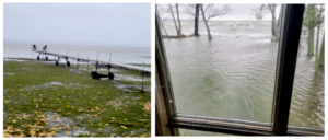
The Winnebago Lakes have large surface area and shallow depths. This combination of lake factors can result in large local rises in water levels when there are sustained winds. In extreme cases in Lake Winnebago, the water level can be a difference of 0.5 feet from one end of the lake to the other. Wind also heavily affects ice formation and ice shoves.

Example: Nov 5, 2022: Left – Fond du Lac, Right – Menasha


Considerations for water level management – Up and Down Stream

(likely not a complete list!!) Aside from Flood Risk Management, which is regulated by the Marshall Order, and navigation, which has set limits due to the 1920 modification to the Marshall Order, considerations are listed in no particular order.

The Army Corps of Engineers – Chicago District regulates water levels in Lake Winnebago by regulating outflow at the dams in Menasha and Neenah under the Federal Marshall Order of 1886. The Marshall Order is intended for flood risk management. Floods can result from rainfall, snowmelt, or rainfall + snowmelt. Water levels are drawn down in winter to increase water storage capacity to minimize flood risk. Even in years with low snowmelt, spring precipitation can result in large amounts of water entering the system.

A modification to the Marshall Order in 1920 was made to address navigation needs on Lake Winnebago. The Order states the limits of regulation are that levels should be between 1.68 ft – 3.45 ft Oshkosh Datum between May 1 – early October. Spring refill occurs around the time of ice out (when all ice is gone).

Ice shoves can cause damage to shorelines, marshes, near-shore habitat and shoreline structures, resulting in property damage as well as erosion, which adds additional sediment and phosphorus to the lakes, impacting water clarity and quality.

Ice can also cause issues for intake pipes. Frazil (anchor) ice forms when fast moving water comes in contact with air below 25°F. Frazil ice can form slush balls that occur throughout the water column, resulting in clogged intake pipes. In extreme cases, plants must shut down, resulting in ice jams. Water levels rise behind the jam and pile more ice on top of itself, blocking flow. This can result in upstream flooding and reduced flow downstream. If there is not complete ice cover on the river, flows are limited to about 4,000 cfs when air temperatures are below 25°F to keep frazil ice from forming.

We love to enjoy ice activities on our lakes, including ice fishing, ice skating, sturgeon spearing, and more. Ice safety for these types of events and activities is taken into consideration for water level management. In general, no major water level changes are planned when ice is forming or begins breaking up.

Even when some areas of the lakes are ice free, there is ice present in other spots on the lake. Click here for ice out dates 2006 – 2024.

About 33% of electricity used in the Fox Valley is due to hydroelectric production on the Lower Fox River. If outflows to the Lower Fox are too low, electricity would need to be produced by other means, potentially causing higher energy costs and/or blackouts. If outflows are too high, problems occur downstream due to intake issues as well as erosion and flooding problems. On the lower Fox River, hydropower generators operate best when flows are 4,000 – 4,500 cfs (ACOE, 2009).

Water level management is a critical part of lake restoration. Water quality is impaired in the Winnebago Lakes due to sediment and phosphorus. Aside from sediment and phosphorus entering our surface waters from runoff and erosion there is legacy phosphorus at the bottom of our lakes. This is referred to as an ‘internal source’, because it comes from inside the lakes themselves.

When sediment gets stirred up due to high wind/wave action, boat wake, etc. and there is no aquatic plants or other structures like breakwalls to mitigate this energy, sediment and phosphorus are brought back up into the water column, contributing to decreased clarity and quality. Additional aquatic plant growth is needed to address this internal source of phosphorus and sediment.

Rooted aquatic plants mitigate wave action, keep sediment at the bottom which improves clarity, take up phosphorus competing with blue-green algae, and provide habitat.

Gradual refill in the spring is necessary to promote aquatic plant growth to improve water clarity and quality. Water levels need to be drawn down in the winter to provide storage capacity for spring precipitation and melt. Overshooting the strategy band in the spring is detrimental to water clarity and quality.

Lake recovery is not an overnight process. Many sources of sediment and phosphorus need to be reduced in order to see improvements to water clarity and quality. Annual and seasonal differences can also add extra complications. Long-term water level management is needed for long-term success.

The summer navigation season on Lake Winnebago is about May 1 – early October. The Marshall Order upon which all regulation strategies are based for Lake Winnebago states that the limits for the navigation season are that water levels are between 1.68 ft – 3.45 ft Oshkosh Datum. Spring refill occurs when the majority of the ice is off the lake, and spring melt runoff and precipitation are taken into consideration during spring refill.

Depending on the year, snow pack can be minimal (ex: 2021 & 2024). This results in shorelines and boat ramps being visible, when usually they are snow and/or ice covered. There can be concern about abnormally low water levels during this time, but this is usually not the case.

Water levels are intentionally drawn down in Winter to make room for snow melt AND spring precipitation. In most years, it is not possible to recreationally boat in March. In 2021, despite little snow melt, the lake met refill targets in time for navigation season. As of March 6, 2024, levels are on track to reach about 1.7 ft Oshkosh Datum around April 1, 2024, which is the set target for the annual strategy.

Angling concerns are often linked to habitat concerns and wildlife concerns, because improved/increased habitat can result in improved angling. This is tied to aquatic plant growth, which requires lower water levels in winter and a gradual refill in spring. Many species, including bluegill, use rooted aquatic habitat. Flow concerns can be linked to species like walleye and lake sturgeon. Lake recovery progress is broadly positive for angling opportunities.

Marina concerns are linked to ice concerns in the winter, flooding concerns in the spring, and recreational boating as well as angler concerns. If water levels are too high during the winter, ice shoves may damage marinas. If water levels are too high in the spring, flooding can occur.

Water based businesses are varied around the Winnebago Lakes, and bring in a considerable amount of revenue to the area. Depending on the business, flooding, habitat, wildlife, ice, shoreline erosion, and more can all be linked to business concerns.

Considerations for shoreline property include ice concerns in the winter and flooding in the spring. If water levels are too high in the winter, ice shoves may come further up the shoreline, resulting in shoreline damage and erosion, and potential damage to structures. Water levels are lowered in winter in order to minimize ice shove damage, and to attempt to have ice shoves further offshore. High water levels during spring refill due to snow melt and precipitation can result in flooding, which can lead to shoreline erosion.

Shoreline property owners should be aware that there is maintenance and erosion concerns with all shoreline property, regardless of water levels.

Shoreline erosion can occur when water levels are high, and/or when water flow rates are high. Ice can also scour shorelines, resulting in erosion. Erosion is a major contributor of sediment and phosphorus to the Winnebago System, which negatively impact water quality and water clarity. Erosion of shoreline habitat like marsh can result in major habitat loss for many species. Erosion can also result in lower property values.

High water levels during the spring can result in flooding of farm fields, resulting in delayed planting or removal of fields from planting for the year. Additional soil may also run off into our surface waters, bringing additional sediment and phosphorus that can negatively impact water quality and clarity.

Habitat includes factors like aquatic plant growth, which provides habitat for many species, including bluegill. Rooted aquatic plants begin to grow when the sediment reaches about 55°F. The current regulation strategy, when met, encourages aquatic plant growth because it allows for a gradual refill in spring. If refill occurs to quickly, rooted aquatic plants may ‘flood out’, as sunlight is further away. Proper water level management can result in rooted plants occurring at deeper depths, resulting in additional habitat.

Flow is another part of habitat that is critical for many species, like lake sturgeon. Management of water levels to provide enough flow for species like sturgeon is especially important during their spawning seasons.

Ice damage/scouring can also occur to marshes, cane beds, and similar habitat. Water level management for ice shoves also affects these types of habitats.

Guidance for habitat protection and management practices can be found in the Linde Plan.

Many different species are affected by water levels aside from their habitat. Animals like turtles, frogs, and muskrats over-winter in or near the water. These animals may not survive if their over-wintering sites are exposed or frozen, which can happen if water levels are drawn down too early. Flooding in the spring can negatively impact habitat and food sources (i.e. wild rice and other aquatic plants) for animals such as wood ducks.

Many of our local wastewater treatment plants rely on intake pipes drawing water in from Lake Winnebago. Water levels can affect the ability to intake and discharge as needed.

Flooding can cause storm sewers to back up and not properly drain, resulting in flooded streets, roads, lawn, and more. Flooding can result in safety issues and property damage. Storm sewer flooding can result in additional organic material entering our waterways, which contributes to poor water clarity and water quality.

Water is withdrawn from the basin for public water utilities and local governments for domestic water supplies, commercial and industrial uses, purposes like firefighting and street washing, and more. Appleton, Oshkosh, Neenah, and Menasha depend on water supplies from Lake Winnebago. About 200,000 people get their drinking water from Lake Winnebago. Many factories rely on intake pipes for water, and water levels, either too high or too low, can affect their ability to intake water.

Public health and harmful algae blooms are another factor to consider with water level management. Harmful algal blooms (HABs), typically occur in summer-early fall, which is when many people are on and around the water. HABs can be exacerbated by heat, and in the Winnebago System, are fueled by phosphorus. Aquatic plants and non-harmful algal species can compete with HABs for nutrients like phosphorus. However, water levels need to be managed to encourage aquatic plant growth.

Lake Winnebago Water Levels are managed by the Army Corps of Engineers – Chicago District, coordinated with their Lake Michigan Project Office in Appleton, WI.

Levels are managed according to a set regulation strategy band.

Understanding Water Level Management for Lake Winnebago

2021 – Lake Winnebago – Annual Winter Drawdown and Low Water

2022 – Ice-out called and spring refill information

2023 – Ice-out for Lake Winnebago and spring refill

Army Corps of Engineers – Lake Winnebago Management Page

Factors considered for daily decision about dam operations (guided by annual strategy)

  • Time of year (annual strategy) – learn more about the annual strategy here
  • Average level of Lake Winnebago
  • Inflows
  • Outflows
  • 5-day rainfall/precipitation forecast
  • Wind speed and direction
  • Ice cover
  • Soil Moisture
  • Snow pack
  • Depth to frost
  • Climate outlook
  • Forecasted water level trend

Join the Winnebago Water Level Assessment team to help develop realistic and achievable water level strategy recommendations and related goals

Click here to learn more

Winnebago Waterways is a Fox-Wolf Watershed Alliance recovery initiative.
Contact us at wwinfo@fwwa.org